Disruptive rain leading to flooding and slippery roads is expected in parts of the Western Cape. (Jaco Marais/Gallo Images/Die Burger)
A warning has been issued by the South African Weather Service for disruptive rainfall resulting in the flooding of roads and susceptible settlements, as well as vehicle accidents due to slippery roads and reduced visibility in parts of the Western Cape.
Impact-based warnings:
A Yellow Level 2 warning for disruptive rainfall resulting in flooding of roads and susceptible settlements, as well as motor vehicle accidents due to slippery roads and reduced visibility, has been issued for the City of Cape Town, Swartland, Stellenbosch, Drakenstein and western Overberg municipalities of the Western Cape.
A Yellow level 2 warning for damaging coastal winds resulting in difficulty navigating at sea, which may lead to small vessels and personal watercraft taking on water and capsizing, has been issued for between Saldanha and Cape Agulhas, spreading to Plettenberg Bay towards the evening while moderating from the west.
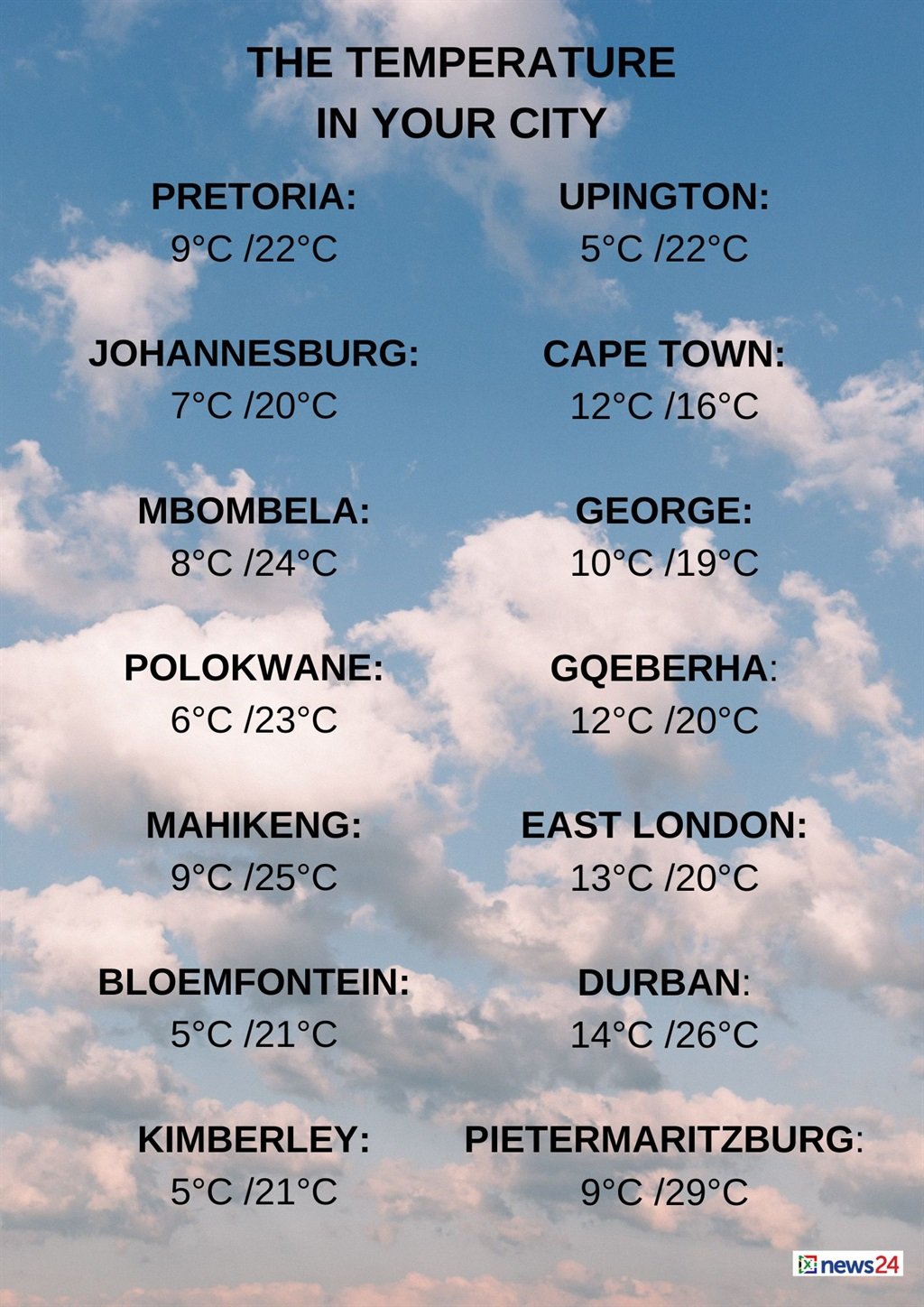
The weather in your region
Fine and cool temperatures are forecast in Gauteng, but it will be warm in the north.
The expected UVB sunburn index is very high.
Mpumalanga will be fine and cool to cold, but warm in the Lowveld.
Fine and cool to warm temperatures are expected in Limpopo.
The North West can expect partly cloudy conditions in the morning. Otherwise fine, windy and cool to warm temperatures are forecast.
Fine, windy and cool conditions are expected in the Free State.
The Northern Cape will have morning fog patches over the southern parts where it will be cloudy with isolated showers and rain from the afternoon.
Otherwise, it will be partly cloudy, windy and cold to cool.
It will be fine in the north-eastern parts.
The wind along the coast will be light and variable at first, otherwise a moderate to fresh northerly wind is expected.
Morning fog patches and drizzle are expected in the Western Cape along the west coast.
Otherwise cloudy, windy and cold to cool conditions are forecast with isolated to scattered showers and rain, which will be widespread along the south-west coast.
The wind along the coast will be a moderate to fresh northerly to north-westerly, becoming strong to gale force between Saldanha Bay and Cape Agulhas.
It will become a fresh to strong westerly to south-westerly from the late afternoon, but the wind will become moderate north of Table Bay from the evening.
The expected UVB sunburn index is low.
The western half of the Eastern Cape will have morning fog patches in the south.
Otherwise, fine and cool temperatures are expected, becoming cloudy with isolated showers and rain from the afternoon.
The wind along the coast will be a light northerly, becoming light to moderate south-westerly by afternoon.
Fine and cool conditions are forecast in the eastern half of the province.
The wind along the coast will be a light westerly.
KwaZulu-Natal will be fine and warm, but cool temperatures are expected in the south-west.
The wind along the coast will be a moderate to fresh northerly to north-easterly, becoming a southerly to south-westerly from the late afternoon.
The expected UVB sunburn index is very high.