Damaging winds and high risk of fires are forecast for Tuesday. (Warren Faidley/Getty Images)
The South
African Weather Service has issued multiple warnings for
damaging winds and high fire risks in two provinces.
Impact-based warnings
A Yellow Level 1 warning has
been issued for damaging winds resulting in a build-up of sand on coastal
routes, localised disruption of small harbours and ports for a short period of
time and of small vessels being at risk of taking on water and capsizing between
Margate and Richards Bay.
A Yellow Level 1 warning for
damaging winds has been issued which could result in difficult driving
conditions, loose debris being blown about and problems for high-sided vehicles,
as well as the risk of rapidly spreading fires over the central parts of the
Northern Cape.
Fire danger warnings
Extremely high fire danger
conditions are expected over the central and north-central parts of the
Northern Cape and Beaufort West Municipality in the Western Cape.
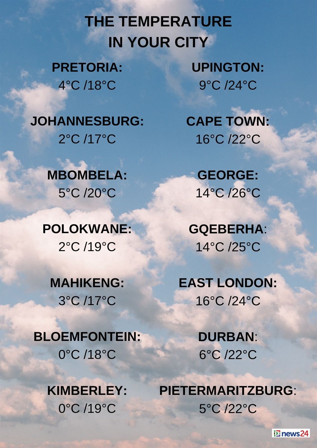
The weather in your region
Morning fog is expected in the
southern parts of Gauteng, otherwise it will be fine and cold to
cool with frost in the morning.
The expected UVB sunburn index
is high.
Mpumalanga will be fine and cool but
cold over the southern Highveld.
Fine and cool conditions are
forecast in Limpopo.
The North West will
be fine and cold to cool, but windy in the extreme west.
Morning frost is expected in
places over the Free State, otherwise fine and cold to cool
temperatures are forecast, but it will be windy in the extreme west.
The Northern Cape can
expect fine and cold to cool conditions, but it will be warm in places and
windy over the central and eastern parts.
It will become partly cloudy in
the west by the afternoon.
The wind along the coast will be
a moderate to fresh northerly to north-easterly becoming light overnight.
Partly cloudy and cool to warm
temperatures are expected in the Western Cape.
It will become cloudy over the
south-western parts by the afternoon with evening rain.
The wind along the coast will be
a moderate to fresh northerly to north-westerly, but strong to near gale in the
south-west.
The expected UVB sunburn index is low.
The western half of the Eastern
Cape can expect fine, windy and cool conditions.
The wind along the coast will be
a moderate to fresh northerly to north-westerly.
Morning frost is forecast for
the north of the eastern half of the province along the escarpment where it
will be cold.
Otherwise, fine and cool
temperatures are expected, but it will be windy over the western interior.
The wind along the coast will be
a moderate to fresh northerly to north-easterly.
KwaZulu-Natal can expect fine and cool
conditions.
The wind along the coast will be
a moderate to fresh northerly to north-easterly reaching strong to gale force
in places south of Richards Bay from midday.
The expected UVB sunburn index is high.