The Weather Service has warmed of damaging winds in five provinces. (Jason Persoff/@Stormdoctor/Getty Images)
The South African Weather Service has issued a warning for disruptive rain in the Western Cape, while damaging winds and a high risk of fire are forecast for most provinces.
Impact-based warning
Yellow Level 1 warning: Damaging wind over the eastern parts of Northern Cape, and western part of the Free State and in places over the Eastern Cape, resulting in difficult driving conditions, blowing around of lose debris, and rapid spreading of veld fires.
Damaging winds resulting in localised disruption in small harbours and/ ports and difficulty in navigation are also expected between Port Edward and Richards Bay in KwaZulu-Natal.
Damaging waves resulting in difficulty in navigation at sea are expected between Slangkop and Cape Agulhas in the Western Cape on Saturday morning.
Yellow Level 1 warning: Disruptive rain resulting in localised flooding of roads and settlements is expected over the Cederberg, Bergrivier and Swartland municipalities in the Western Cape.
Fire danger warning
Extremely high fire danger conditions are expected over the eastern half of the Northern Cape, and western half of both the Free State and North West, and the Beaufort West Municipality in the Western Cape as well as the Chris Hani, Joe Gqabi and Amathole district municipalities and Dr Beyers Naude Local Municipality in the Eastern Cape.
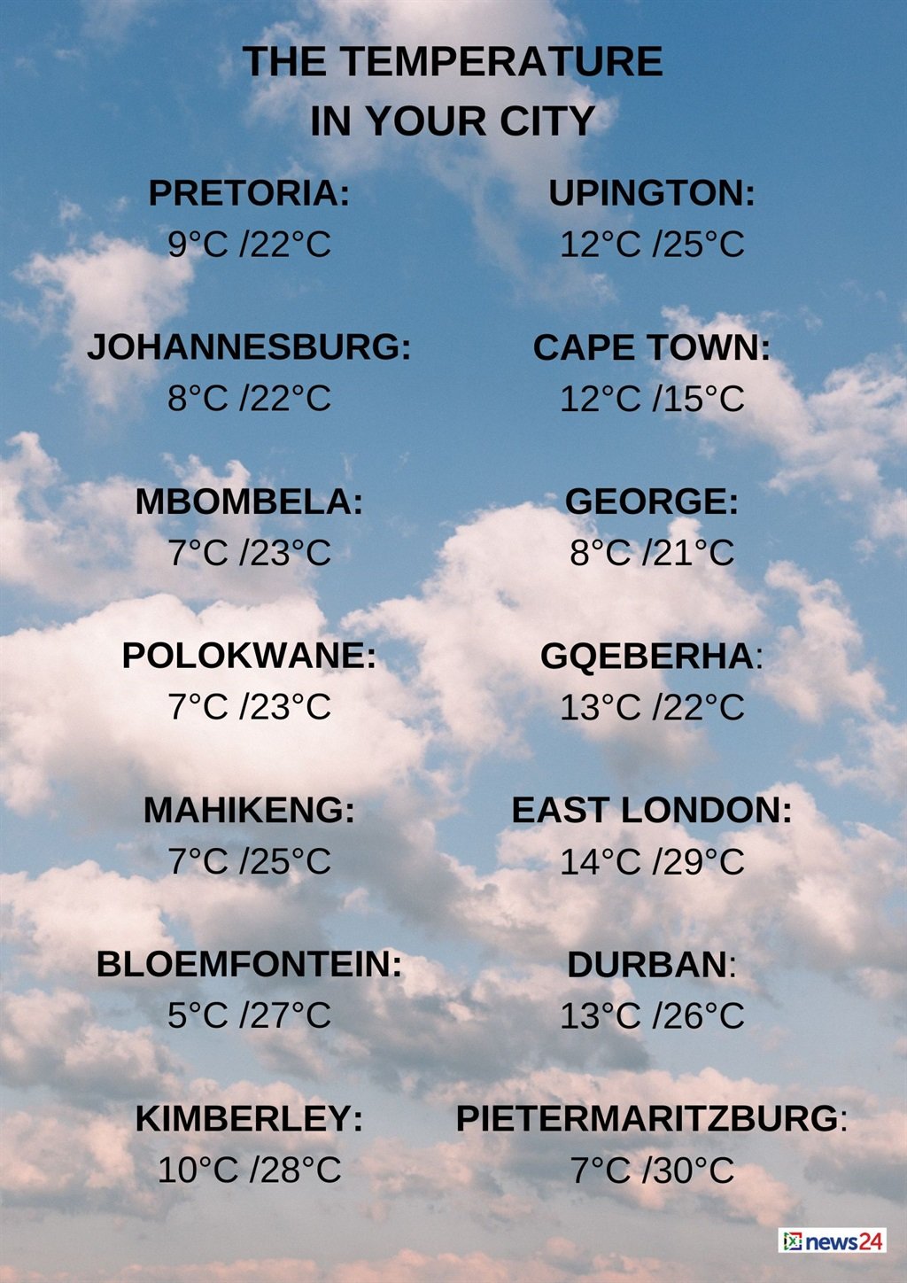
Weather in your region
Gauteng will be fine and warm. The expected UVB sunburn index is high.
Morning fog patches are expected along the escarpment of Mpumalanga, otherwise it will be partly cloudy and cool but warm on the Lowveld.
Limpopo will see morning fog patches over the central and south-eastern parts, otherwise fine and cool to warm but partly cloudy in the east clearing by the evening.
The North West and Free State will be fine, windy and cool to warm.
Cloudy and cool conditions are forecast along coast of the Northern Cape.
It will be partly cloudy and cold with light rain in the south-west, otherwise fine and warm but windy over the eastern parts.
The wind along the coast will be fresh north-westerly becoming light southerly in the afternoon.
The Western Cape will be cloudy and cold with isolated rain showers in the west but scattered in the south-west, spreading to the central parts in the afternoon, otherwise partly cloudy and cool. It will be windy in places.
The wind along the coast will be fresh to strong north-westerly but light and variable along the south coast at first, becoming moderate south-westerly in the afternoon. The expected UVB sunburn index is low.
The western half of the Eastern Cape will be fine and cool to warm, becoming partly cloudy in the afternoon with isolated showers and rain in the south.
It will become cloudy along the coast with light rain in the evening. It will be windy in places over the interior. The wind along the coast will be moderate to fresh south-westerly.
The eastern half of the province will be cool in places north of the escarpment, otherwise fine, windy and warm to hot, becoming partly cloudy in the west and central parts in the afternoon, with isolated showers and rain in the south.
The wind along the coast will be moderate north-easterly, becoming moderate to fresh south-westerly from the west in the afternoon.
KwaZulu-Natal will be partly cloudy with morning fog patches in the northern parts, otherwise fine and warm to hot.
The wind along the coast will be strong northerly to north-easterly, reaching gale force in places. The expected UVB sunburn index is high.


