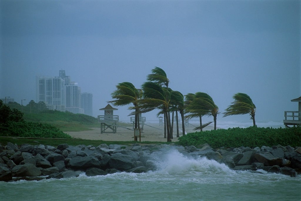
Damaging winds and waves are forecast in at least three provinces. (Warren Faidley/Getty Images)
Friday could see damaging winds and waves resulting in difficult navigation at sea, disruption to harbours and ports, as well as potential damage to property and difficulty driving, the South African Weather Service has warned.
Impact-based warnings
A Yellow Level 2 warning for damaging waves resulting in difficulty in navigation at sea and putting small vessels at risk of taking on water and capsizing has been issued between Saldanha Bay and Plettenberg Bay.
A Yellow Level 4 warning has been issued for damaging wind and waves resulting in disruption to harbours/ports, difficulty in navigation, with vessels at risk of capsizing, dragging anchors and breaking mooring lines between Plettenberg Bay and Port Edward.
A Yellow Level 2 warning for damaging winds resulting in damage to property, difficult driving conditions and localised communication and power interruptions has been issued for Kouga, Nelson Mandela Bay, Ndlambe, Makana, Ngqushwa and Buffalo City local municipalities of the Eastern Cape.
Advisories
Very cold conditions and light snow are expected in places over the high ground of the Eastern Cape interior.
A series of intense cold fronts are expected to affect the Western Cape, Northern Cape and Eastern Cape between 7 and 12 July.
The public and small stock farmers are advised that snowfalls, very cold conditions, strong coastal and interior winds, and very rough seas can be expected, with heavy rainfall likely over the western parts of the Western Cape.
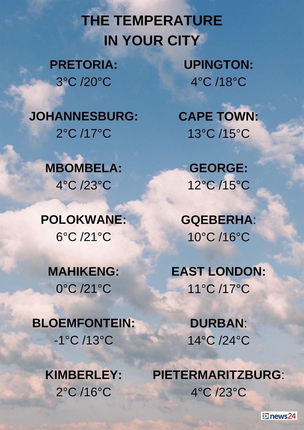
The weather in your region
Gauteng will have morning frost in places, otherwise it will be fine and cool, but cold in the south.
The expected UVB sunburn index is high.
Morning frost is expected in places on Mpumalanga’s Highveld. Otherwise, fine and cold to cool temperatures are forecast, but it will be warm in the Lowveld.
Limpopo can expect fine and cool to warm conditions.
Morning frost is forecast in places over the central and western parts of the North West, otherwise it will be fine and cool.
Windy conditions are expected in the south.
Morning frost is expected in parts of the Free State.
Otherwise, fine, windy and cold to cool temperatures are forecast, becoming partly cloudy in the south with light afternoon showers in the extreme south-east.
The Northern Cape will have morning frost in the east.
Otherwise, it will be fine and cold to cool, but partly cloudy over the central and southern parts in the morning, with light showers in the extreme south-east.
Morning fog patches are expected over the western and central interior.
The wind along the coast will be a light southerly, becoming fresh to strong in the afternoon.
Brace yourselves as a series of cold fronts approach the country towards the weekend. Temperatures are expected to drop significantly and snow is forecast over the mountains of the Eastern and Western Cape Provinces this weekend.?????? pic.twitter.com/h68tvmo5HR
— SA Weather Service (@SAWeatherServic) July 4, 2024
Cloudy to partly cloudy conditions are expected in the Western Cape, it will be cold to cool with isolated morning showers over the southern and western parts.
The wind along the coast will be a fresh westerly to south-westerly, but strong to near gale force along the south coast, becoming light to moderate southerly in the west and south-west by evening.
The expected UVB sunburn index is low.
The western half of the Eastern Cape will be partly cloudy to cloudy, windy and cold to very cold. Isolated showers and rain can be expected, but scattered along the south coast.
Light snowfalls are expected over the high-lying areas.
The wind along the coast will be a strong to gale force westerly.
Fine and cold to very cold temperatures are forecast for the eastern half of the province, becoming cloudy in places, with isolated light showers in the west and light snowfalls over the northern interior.
The wind along the coast will be a light to moderate north-westerly, becoming strong south-westerly.
KwaZulu-Natal can expect fine and cool conditions, but it will be warm in the north-east.
The wind along the coast will be a moderate westerly to north-westerly in the morning.
Otherwise, a moderate to fresh north-easterly is forecast, becoming a southerly to south-easterly from the south by late morning.
The expected UVB sunburn index is very high.