Fine and warm conditions are expected in most parts of the country. (Manuel Breva Colmeiro/Getty Images)
The South African Weather Service has forecast fine and warm conditions for most of the country, but has issued warnings for a high risk of fires and damaging winds in some parts.
Impact-based warnings
A Yellow Level 1 warning for damaging winds is expected over the southern parts of the ZF Mgcawu and Pixley Ka Seme districts in the Northern Cape, as well as the Dr Beyers Naude Local Municipality in Eastern Cape and Central Karoo in the Western Cape resulting in difficult driving conditions and the rapid spreading of veld fires.
Fire danger warnings
Extremely high fire danger conditions are expected over most parts of the Northern Cape, western parts of the North West, southern parts of the Free State, north-western parts of the Western Cape and most parts of the Eastern Cape.
Warnings for Tomorrow: 20 Aug ’24A. Yellow L1: Damaging Winds.IMPACT: Difficult driving conditions and rapid spread of veld fires.AREA: S parts of ZF Mgcawu and Pixley Ka Seme districts of N Cape, Dr Beyers Naude local municipality of E Cape and Central Karoo of W Cape. pic.twitter.com/s9PnUvsv6Z
— SA Weather Service (@SAWeatherServic) August 19, 2024
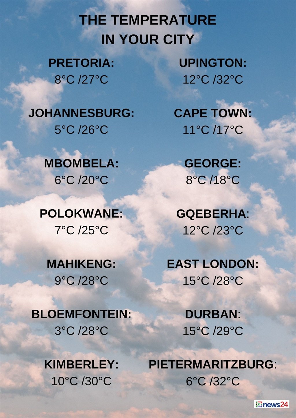
The weather in your region
Gauteng can expect fine and warm temperatures.
The expected UVB sunburn index is high.
Fine and warm conditions are forecast in Mpumalanga, but it will be cool along the escarpment.
Limpopo will be fine and warm.
Fine, warm, and windy conditions are expected in the western parts of the North West.
The Free State can expect to be windy in the south, otherwise it will be fine and warm.
Fine, windy and cool to warm temperatures are forecast in the Northern Cape, but hot temperatures are expected in the north-west.
The wind along the coast will be a moderate to fresh southerly to south-easterly.
The Western Cape will have morning fog along the coastal belt, otherwise it will be fine and cool to warm becoming cloudy in the extreme west by the evening.
The wind along the coast will be a moderate to fresh westerly east of Cape Agulhas, becoming light easterly, but a moderate to fresh southerly north wind off Saldanha Bay.
It will become a moderate to fresh northerly to north-westerly wind from the afternoon.
Otherwise, a moderate to fresh westerly wind is forecast, reaching strong south of Table Bay from the evening.
The expected UVB sunburn index is moderate.
Windy conditions are expected over the interior of the western half of the Eastern Cape, otherwise it will be fine and warm but cool along the coast.
The wind along the coast will be moderate to fresh south-westerly, reaching strong in places, becoming a light southerly wind in the afternoon, but easterly in the evening.
The eastern half of the province will also be windy over the interior, otherwise fine and warm temperatures are forecast.
The wind along the coast will be a light northerly in the early morning, otherwise a light to moderate north-easterly wind is expected.
KwaZulu-Natal will be partly cloudy with morning fog in the north-east, otherwise fine and warm to hot conditions are forecast.
The wind along the coast will be a moderate to fresh north-westerly in the extreme north until late morning, otherwise a northerly to north-easterly wind is forecast.
The expected UVB sunburn index is high.


